
|
Windsor Castle Park EntrancesWindsor Castle Park is easily accessible from downtown Smithfield via several entrances, making the town's wonderful shops, restaurants, attractions and lodgers within easy walking distance. There is ample parking at the dog park/natural playscape area (#1/2 on the park map), as well as near the outfitters station (#10 on the park map).
The main entrance and parking facility is located on Jericho Road off Cedar Street. Access from the historic downtown area is available at the end of South Mason Street via the Mason Street Bridge (#5 on the park map). Parking for this entrance is in the downtown area, as well as at a shared parking lot at Trinity United Methodist Church at the corner of Mason and Cedar Streets. A third entrance to the park is available from the Smithfield Station parking lot. PLEASE NOTE: As a courtesy to Smithfield Station, regular users of the trails are asked to park their cars in the main parking lot on Jericho Road. |
|
Pedestrian access bridgesThe Mason Street Bridge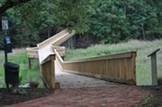
This bridge provides a link to the outer loop trails from downtown by way of Mason Street. Walkers entering the park via this route pass through a beautifully landscaped “mini park” adorned with brick entrance columns and a brick paver walk that leads to the bridge. These surroundings provide a perfect setting for rest, meditation and watching wildlife. An overlook with benches is located midway that allows walkers the opportunity to stop, rest and enjoy the panoramic view of Little Creek. (#5 on the park map)
The Ravine Bridge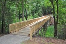
This bridge links the outer loop of the park trails as it crosses a natural ravine, a watershed for the surrounding park area. It is raised approximately fifteen feet above the ravine forest floor. Just over the bridge railing, on the south side, are the remnants of an earthen dam that was used in the early eighteen hundreds to trap fresh water in the winter time. After the water froze, ice blocks were cut and stored in the hill side and use for cooling on the farm in the summer. Around dusk, if you are lucky and very still, you might see deer passing beneath the bridge. (#6 on the park map)
The Jericho Bridge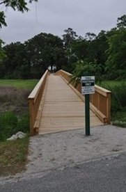
This bridge links the outer loop of the park trails as it crosses the marsh area surrounding Little Creek just off Jericho Road. It also allows access to the trails for walkers from the downtown area by way of Jericho Road. (#7 on the park map
The Station Bridge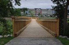
This bridge provides a link to the outer loop trails from South Church Street and the Smithfield Station Parking lot. An overlook is situated approximately midway adjacent to Little Creek. Two benches provide a place for resting and viewing wildlife and the many surrounding picturesque sites. Parking is limited in the Smithfield Station parking lot. (#8 on the park map) The Overlook Bridge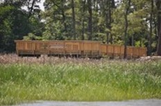
This bridge connects the trails to a deck strategically located at a bend in Cypress Creek that allows for panoramic viewing of the surrounding marsh. Benches are provided on the deck for resting, meditating, reading and wildlife spotting. Bald Eagles, osprey, deer, muskrat, and otter have been observed from the deck. (#12 on the park map)
|